Monsoon Advances Across India as Delhi Braces for Severe Thunderstorms
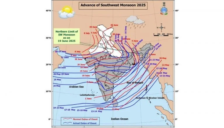
The southwest monsoon expanded its footprint across India on Tuesday, entering Mumbai and major sections of Maharashtra, Telangana, and Odisha. According to the India Meteorological Department, the weather system also penetrated deeper into Chhattisgarh, Jharkhand, and Bihar, bringing widespread rainfall to the subcontinent.
Key Highlights
- The southwest monsoon covered Mumbai, Telangana, Odisha, and parts of Bihar and Jharkhand on Tuesday.
- Atmospheric conditions support further monsoon expansion into Gujarat and Madhya Pradesh over the next 2 to 3 days.
- High-intensity rainfall between 7 cm and 20 cm is forecast for the west coast and Northeast India this week.
- Delhi faces severe thunderstorm advisories with projected wind gusts reaching up to 60 kmph.
Atmospheric dynamics remain highly favorable for the precipitation front to push into parts of Gujarat, additional territory in Maharashtra and Chhattisgarh, and sectors of Madhya Pradesh over the next 2 to 3 days. The remaining zones of Jharkhand and Bihar, along with portions of Uttar Pradesh, will transition under monsoon influence during the subsequent 3 to 4 days.
The meteorological office projected intense precipitation cycles, estimating accumulations between 7 cm and 20 cm, along the western coast, throughout Northeast India, and across Sub-Himalayan West Bengal and Sikkim during the weekly cycle.
Concurrently, severe heatwave trends will persist over East Uttar Pradesh for the upcoming 4 to 5 days. Regions within Vidarbha, southeast Madhya Pradesh, and Bihar are similarly projected to endure heatwave duress over the next 2 to 3 days.
The national capital recorded a minor cooling trend, with maximum temperatures dropping 1 to 2 degrees Celsius over the preceding 24 hours, while overnight minimums held steady.
Maximum temperatures across Delhi fluctuated between 38°C and 39°C, whereas minimums stabilized between 25°C and 27°C. These nighttime values plunged notably below seasonal norms by 3.1°C to 5.0°C at select pockets, and remained 1.6°C to 3.0°C lower across multiple sectors. Peak daytime temperatures registered below normal at isolated spots and stayed near average elsewhere.
Partial cloud cover dominated the metropolitan skies over the last day, driven by westerly winds blowing at 22 kmph with maximum gusts reaching 33 kmph.
For June 23, meteorologists predicted partially cloudy skies paired with potential light showers, thunderstorms, electrical activity, and strong wind currents during the afternoon and evening. Wind velocities could hit 30-40 kmph, gusting up to 50 kmph, while maximum temperatures will hover between 39°C and 41°C.
On June 24, scattered cloud formations will persist, bringing a likelihood of afternoon or evening thunderstorm developments. Ambient temperatures are expected to oscillate between daytime highs of 39°C-41°C and nighttime lows of 26°C-28°C.
Similar atmospheric conditions are anticipated on June 25, featuring partial cloud cover alongside daytime maximums between 38°C and 40°C and nighttime minimums between 27°C and 29°C.
For June 26, official forecasts indicate partly cloudy conditions with a vulnerability to light rain, lightning strikes, and gusty winds ranging from 20-30 kmph to 40 kmph during later hours. Thermal readings will settle between 39°C and 41°C by day and 27°C and 29°C by night.
Thunderstorm Advisory
The weather agency issued a formal warning detailing thunderstorms linked with lightning strikes and wind speeds of 40-50 kmph, scaling to 60 kmph in specific areas, alongside dust-storm activity across Delhi during this window.
Potential structural hazards include the uprooting of trees, snapping of branches, destruction of standing agricultural yields, and infrastructure blackouts affecting power and telecommunication networks. Minor damage to fragile dwellings and the displacement of unanchored items are also highly probable.
Safety directives advise citizens to track immediate meteorological bulletins, restrict discretionary travel during severe weather, remain indoors, and lock exterior access points. Safety protocols explicitly warn against seeking cover under tree canopies, operating electrical equipment during lightning strikes, standing near metal infrastructure, or entering open water zones during active storms.
Future Outlook
The current trajectory of the southwest monsoon points toward an optimal alignment of moisture-laden winds and low-pressure systems, facilitating a timely arrival across central and northwestern agricultural belts. If the projected advance holds, the standard deficit observed during early June across major grain-producing states could narrow significantly before July.
Over the coming week, municipal corporations in vulnerable coastal cities like Mumbai must accelerate drainage clearance to mitigate localized flooding, while administrative bodies in the north prepare grids for high-velocity wind disruptions.
FAQs
Which Indian states have seen the latest advance of the monsoon?
The monsoon has successfully progressed into substantial parts of Maharashtra, including Mumbai, alongside the remaining portions of Telangana and Odisha. It has also expanded further into regions within Chhattisgarh, Jharkhand, and Bihar.
What are the projected wind speeds and impacts for Delhi during the storm warnings?
Delhi is expected to experience gusty winds ranging between 40 kmph and 50 kmph, with isolated speeds reaching 60 kmph. Anticipated impacts include uprooted trees, damaged crops, power outages, communication line failures, and structural harm to loose objects.
How long are the heatwave conditions expected to last in northern and central India?
Heatwave conditions are forecast to persist over East Uttar Pradesh for 4 to 5 days. Meanwhile, the regions of Vidarbha, southeast Madhya Pradesh, and Bihar will likely experience heatwaves for another 2 to 3 days before the monsoon brings relief.